
Circular hike to Lake Nero, 2246 m – Maira Valley
Canosio (CN) · Piemonte
 T
Not accessible
T
Not accessible
Trail Map
Il tracciato completo con i punti di interesse. Puoi cambiare il tipo di mappa dal comando in alto a destra e attivare rifugi, fontane e parcheggi dal pannello a sinistra.
Elevation Profile
Description
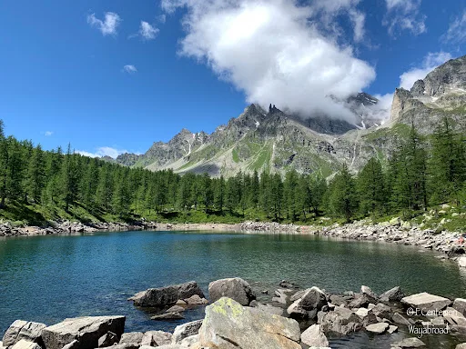
Black Lake Ring – Canosio A circular route that captivates with its open views and the discovery of one of the most evocative alpine lakes in the Maritime Alps: Lago Nero, a silent mirror nestled between high-altitude rocks. The route The starting point is at Grange Selvest, in the municipality of Canosio. After crossing a wooden bridge over the stream, the trail winds through a larch forest that gently accompanies the climb to Grange Culausa: a panoramic location from which the imposing silhouette of Rocca la Meja looms on the horizon. Continuing upwards, you reach the pass at 2,304 m above sea level, the gateway to the basin that hosts Lago Nero. Here, the landscape changes: the lake opens like a natural balcony overlooking the Preit di Canosio valley, with that suspended and silent atmosphere that only high mountain locations can offer. The Descent: Following the right bank of the lake, the trail descends towards Grange Chiacarloso (2,080 m) and then further towards Grange Colombero Sottano. Those wishing to add a historically significant stop can make a short detour to the Lapide degli Alpini (Alpine Memorial), located at the site where twenty-three soldiers from the Dronero Brigade lost their lives on January 30, 1937, when they were swept away by an avalanche during a winter exercise. The return journey takes place on a dirt road, which leads easily back to Grange Selvest and the rest area.
Gallery
Navigate with QR Code
Scan with your smartphone to start guided navigation directly on the trail.
Trail QR Code
Frame the QR code to open the full navigation

Partenza
Km 0.00
Accessibility for People with Disabilities
Il livello di accessibilità è dichiarato dall'ente che gestisce il percorso. Se trovi una difformità, segnalacela: la correggiamo insieme al Comune.
Clothing (Onion technique)
Trekking boots: Footwear with a good treaded sole is required, preferably waterproof (such as Gore-Tex).
Breathable clothing: Technical T-shirt (avoid cotton).
Fleece or long-sleeved shirt: Wear in shaded areas or at the lake.
Waterproof/Windproof Jacket: A windproof jacket or cape is essential in the mountains.
Trekking trousers: Long or modular.
Hat and sunglasses: The sun can be strong at high altitude.
Spare parts: A dry T-shirt to change into after the climb.
Equipment in the Backpack
Hiking backpack: With a capacity of 20-30 liters.
Telescopic poles: Recommended to make climbing easier and protect your knees when descending.
Water bottle or Camelbak: At least 1.5 liters of water, especially if it's hot.
Packed lunch and snacks: Energy bars, dried fruit, or chocolate.
First aid kit: Blister plasters, disinfectant.
Sunscreen: High protection.
Map or navigation app: Paper map or GPS track (apps like trailgo.it).
Power bank: To keep your phone charged.
For additional information, contact the local tourist office or the reference shelter for the trail.
44,42183, 7,04925

